Biography:
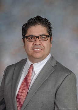
Received his PhD degree in Geomatics Engineering - Remote Sensing from University of New Brunswick (UNB) in 2012, Dr. Salehi joined State University of New York College of Environmental Science and Forestry (SUNY ESF) in September 2018 as an Assistant Professor of Remote Sensing Engineering in the Department of Environmental Resource Engineering (ERE). He is currently an Associate Professor at ESF. Prior to ESF, Dr Salehi was a senior Remote Sensing Engineer with C-CORE, a Canadian-based world leading company in the area of remote sensing of northern latitudes as part of LOOKNorth , a Canadian center of excellence for commercialization and research of remote sensing from 2013-2018. From 2014-2018 he was concurrently a cross-appointed professor with the Department of Electrical Engineering and Computer Science (DEECS), Memorial University of Newfoundland (MUN) where he conducted extensive research and was the major professor of 6 PhD and MSc students and a postdoctoral fellow and established and taught three new courses. From 2012 -2013 Dr Salehi was a NSERC post-doctoral visiting fellow in Canadian Government Laboratories at Earth Observation, Science and Technology Branch of Agriculture and Agri-food Canada in Ottawa.
Dr. Salehi has over 20 years of academic and industrial R&D experience in geospatial engineering and remote sensing. His research areas include machine learning and applications development of multispectral, synthetic aperture radar (SAR), and UAV data for environment monitoring with focus on wetland, forest, and water quality mapping and change monitoring. He is the co-author of more than 70 peer-reviewed journal papers and book chapters with nearly 6000 citations and a Google Scholar h-index of 36 as of August 2024. He has many years of teaching experience in remote sensing (optical/ SAR), photogrammetry and UAV, machine learning as well as surveying and geomatics engineering in three universities in Canada and the U.S. Since 2014, Bahram has been the principal supervisor (major professor) of 1 post-doctoral fellow, 9 PhD students, 4 MSc students, and several undergraduate and intern students.
Since 2014, he has been awarded several industrial and governments (Canada and the US) research projects and grants (including the Canada’s NSERC Discovery grant-similar to NSF CAREER) securing a total of some $2.5 m of external funding as PI. Dr Salehi’s current research is focusing on remote sensing of water quality for inland waters, state-wide and regional extent forest above ground biomass and carbon storage change detection and mapping, nation-wide (Canada and the US) wetland inventory mapping (in 2020 he finished (as PI) and published the first high resolution nation-wide wetland inventory of Canada. Dr Salehi is actively involved in many professional societies and has served in various roles including the national executive director for Canadian Remote Sensing Society (CRSS), National Director, for the Unmanned Aerial System Division (UASD) of ASPRS, the co-chair of Commission III/Working group III ( SAR remote sensing) of ISPRS. In 2022 and 2024 he co-organized and chaired the IEEE-STRATUS (a UAV Remote Sensing Conference) hosting more than 150 professionals and students from across the U.S and Canada.
Bahram is a recipient of a number of awards including the 2019 early career achievement medal from the Canadian Remote Sensing Society and Outstanding Service Award in 2024 from ASPRS. He is a licensed member of Canadian Professional Engineer (P.Eng), a previous licensed project management professional (PMP), and a senior member of IEEE (SM. IEEE). In 2024 Dr. Salehi was ranked among the top 3 scholars in remote sensing in the United States in the prior 5-Year period by ScholarGPS, a premier online resource for analyzing scholarly activities.
Education:
Ph.D. : Remote Sensing Engineering ----------------------------------------------------------------------------- 2008-2012
University of New Brunswick , Fredericton, NB, Canada
M.Sc. : Photogrammetry and Remote Sensing Engineering ---------------------------------------------- 2002-2005
K. N. Toosi, University of Technology , Tehran, Iran
B.Sc. : Surveying and Geomatics Engineering ---------------------------------------------------------------- 1997-2002
University of Tehran , Tehran, Iran
Professional Experience:
Associate Professor, SUNY-ESF, USA --------------------------------------------------------------------------- 2024 - Present
Assistant Professor, SUNY-ESF, USA --------------------------------------------------------------------------- 2018 - 2024
Adjunct Professor, Memorial University, Canada ------------------------------------------------------------ 2014 - 2022
Senior Remote Sensing Engineer, C-CORE, Canada ------------------------------------------------------- 2013 - 2018
NSERC Post-Doctoral Visiting Fellow, AAFC, Canada ----------------------------------------------------- 2012 - 2013
Research Assistant - PhD Student, University of New Brunswick, Canada ------------------------ 2008 - 2012
Stipend Instructor, University of New Brunswick, Canada ----------------------------------------------- 2009 - 2011
Research Assistant - MSc. Student, K.N. Toosi University of Tech., Iran --------------------------- 2002 - 2005
Remote Sensing Specialist, Farazamin Consulting Engineers, Iran ---------------------------------- 2006 - 2008
GIS and Photogrammetry Analyst, Farazamin Consulting Engineers, Iran ------------------------- 2003 - 2006
Surveying & Geomatics Engineer, ZaviehYab Consulting Engineers, Iran ------------------------- 2000 - 2002
Professional Appointments:
National Director, American Society for Photogrammetry and Remote Sensing (ASPRS) Unmanned Aerial System Division (UASD), 2024 - Present.
General Chair, IEEE- STRATUS, IEEE-STRATUS (UAV Remote Sensing) Conference. 2022 and 2024.
Co-Chair Commission III, Work group III, International Society for Photogrammetry and Remote Sensing (ISPRS), 2022-2026
National Deputy Director, American Society for Photogrammetry and Remote Sensing (ASPRS) Unmanned Aerial System Division (UASD), 2022 - 2023.
Co-organizer and Technical Program Chair, IEEE-STRATUS (UAV Remote Sensing) Conference. 2019 - 2021.
Director, Canadian Remote Sensing Society, 2016 - 2020.
Secretary, Commission III, WGIII, ISPRS-International Society for Photogrammetry and Remote Sensing Society, 2016-2020.
Professional Societies Membership
Registered Professional Engineer, Association of Professional Engineers and Geoscientists of Newfoundland and Labrador (PEGNL), Canada, 2014 - present
Registered Professional Engineer, Association of Professional Engineers and Geoscientists of New Brunswick (PEGNB), Canada, 2012-2014
IEEE Geoscience and Remote Sensing Society, 2012 - present
Canadian Institute of Geomatics, 2012 - present
American Geophysical Union, 2015 - present
American Society for Photogrammetry and Remote Sensing, 2009 - present
Association of University of New Brunswick Teachers (AUNBT), 2009-2012
Association of New Brunswick Land Surveyors 2008 - 2012
The Canadian Association of Geographers 2012- 2014
Honors and Awards
|
|
Outstanding Service Award, American Society for Photogrammetry and Remote Sensing (ASPRS), 2024.
|
|
|
Co-Author of the Best Cover Paper of 2019 by Remote Sensing - MDPI Open Access Journal
|
|
|
Recipient of 2019 Early-Career Achievements Medal from Canadian Remote Sensing Society
|
|
|
Invited Speaker at Google Booth at AGU 2019 Fall Conference, San Francisco, Dec 10, 2019
|
|
|
ESRI CANADA 2020 Map Calendar Contest winner (together with my student Masoud Mahdianpari)
|
|
|
IEEE Senior Member-SMIEEE, 2017
|
|
|
"Distinct PhD Dissertation" by my student, Masoud Mahdianpari, May 2019, Memorial University, Canada
|
|
|
"Distinct PhD Dissertation" by my student, Fariba Mohammadimanesh, May 2019, Memorial University, Canada
|
|
|
Feature Paper of Remote Sensing Open access Journal-MDPI, 2018
|
|
|
IEEE NECEC 2016 David Collett Best Industry Paper
|
|
|
MITACS Accelerate Grant, 2017-2019
|
|
|
NSERC Discovery Grant, 2015-2019
|
|
|
Environment Canada NWCF, 2015-2018
|
|
|
Environment Canada AEI Fund, 2015-2018
|
|
|
Newfoundland and Labrador RDC Ignite Grant, 2014-2016
|
|
|
NSERC Visiting Fellowship in Canadian Government Laboratories, 2012-2013
|
|
|
Oral presentation award, Science and Engineering, GRC, UNB, Canada, April 2012
|
|
|
2012 ERDAS - DigitalGlobe Geospatial Challenge , WorldView-2 Imagery
|
|
|
First Paper Prize, Dep Graduate Student Paper Competition, UNB, Canada, 2011
|
|
|
2011 DigitalGlobe 8-Band Research Challenge Contest, WorldView-2 Imagery
|
|
|
UNB Research Assistantship Award, 2008-2012
|
|
|
UNB Graduate Research Assistantship Award , 2008-2012
|
|
|
K. N. Toosi University of Technology Elite (Selective) Researcher Award , 2005
|
|
|
Int. Assoc. for Exch. of Students for Technical Exp. (IAESTE) Award, Croatia 2004
|
|
|
Ranked 12 (among more than 3K), the Nation-wide Graduate Studies exam, Geomatics Eng., Iran, 2002.
|
|
|
Ranked 632 (among more than 200K), the highly competitive Nation-wide university entrance exam for undergraduate studies, Iran, 1997. |
